ARTIST: William Guthrie
PUBLISHER: Published as the Act directs January 1st 1785 by C. Dilly & G. Robinson, London.
MEDIUM: Copper plate engraving
DATE: 1785.
EDITION SIZE: 13 1/2 x 13" (343 x 330 mm) plus margins.
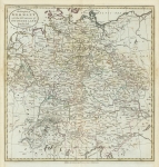
DESCRIPTION: This fine map appeared in William Guthrie's atlas, "A new geographical, historical, and commercial grammar; and present state of the several kingdoms of the world...." A very nice example of this map.
ADDITIONAL INFO:
CONDITION: Good condition save for some minor repairs. Backed on rice paper. Original outline hand color.
REFERENCE:


 Login / Register
 Basket