ARTIST: J. Peck
PUBLISHER: Published by J.H. Colton, 172 William St. New York.
MEDIUM: Engraving,
DATE: 1864
EDITION SIZE: 41 x 27 3/8" (1043 x 696 mm) plus margins.
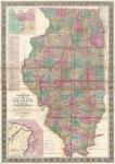
DESCRIPTION: The title continues with "Also exhibiting the Internal Improvements, distances between Towns, Villages, & Post Offices: the outlines of Prairies, woodlands, Marshes & the lands donated to the State by the Genl. Govt for the purpose of Internal Improvement." By J. M. Peck and John Messinger. and published by Colton. The two insets are of the cities of Chicago and St. Louis. Drawn on a scale of ten miles to an inch.
ADDITIONAL INFO: 1862 edition. Still in original covers.
CONDITION: Good condition and color.
REFERENCE:


 Login / Register
 Basket