ARTIST: John Speed
PUBLISHER: Published by Thomas Bassett and Richard Chiswell.
MEDIUM: Copper plate engraving.
DATE: 1626, (1676.)
EDITION SIZE: Image size 15 1/8 x 20" (38.5 x 50.6 cm) plus margins.
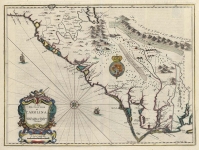
DESCRIPTION: A decorative and highly desirable map of the Americas. This map appeared in Speed's atlas" Prospect of the Most Formed Parts of the World" - the first English produced world atlas. The copper plates were engraved by Abraham Goos in Amsterdam which was the center of the European map trade. This was the first map published in an atlas that depicted California not as a peninsula, but as an island, a cartographic misconception that endured for nearly 100 years. The map has a fairly accurate rendering of the East Coast, especially between the Chesapeake Bay and Cape Cod. Many English colonies appear on the map, including Plymouth in the northeast and Iames Citti in Virginia. The northwest coastline is very faint. Surrounding this map on two sides are images of indigenous peoples found from Greenland to the Straits of Magellan. The figures on the left represent natives from the north, while figures on the right side are southern natives. Eight town views appear on top. Although the map depicts the English presence in North America, surprisingly none of the town views are English colonies. Rather, they show important early views of Havana, St. Domingo, and Rio, among others. An inset map shows Greenland, Baffin's Bay, and Iceland. On the verso is a two-page English text "The Description of America". The fourth state of four.
ADDITIONAL INFO:
CONDITION: Good condition save for tear in lower portion of image just left of the centerfold. Hand colored.
REFERENCE: Burden 217, state 4; McLaughlin, The Mapping of California as an Island, No. 3; p. 5 in "California as an Island" by R. V. Tooley.


 Login / Register
 Basket