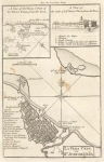
ARTIST: Thomas Kitchin
PUBLISHER: London, published according to Act of Parliment Nov. 1st, 1762 by J. Boydell & W. Willock in Cornhill.
MEDIUM: Copper plate engraving,
DATE: 1762
EDITION SIZE: 17 1/4 x 24" (437 x 507 mm) plus margins.
DESCRIPTION: A rare battle plan of Havana, Cuba shown during the Seven Years War. This plan shows the placement of British forces under General Pocock. At the conclusion of this battle the British captured the Spanish city of Havana. In 1763, Havana was exchanged back to the Spanish for Florida. In each of the lower corners are reference keys noting key gun emplacement, locations etc.
ADDITIONAL INFO:
CONDITION: Very good condition. Black & white.
REFERENCE:


 Login / Register
 Basket