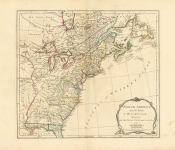
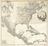
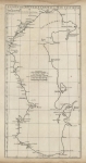
ARTIST: Jean Baptiste D'Anville
PUBLISHER: Published by P. Santini, Venise.
MEDIUM: Copper engraving; with original outline color,
DATE: 1775
EDITION SIZE: 18 3/4 x 22 1/4" (478 x 564 mm).
DESCRIPTION: From Atlas Universel, Venice, 1776-84. This is a detailed map of the Great Lakes and the upper Mississippi valley, based upon the wealth of information available to the French. The map extends north to the Falls of St. Anthony, where a legend indicates that the source of the Mississippi is still unknown. To the west is the Missouri River, with its tributaries carefully mapped.
ADDITIONAL INFO:
CONDITION: Fine condition and color.
REFERENCE:


 Login / Register
 Basket