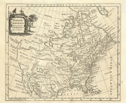
ARTIST: Thomas Kitchin
PUBLISHER: London. Published by Laurie & Whittle, No. 53 Fleet Street... 12 May, 1794.
MEDIUM: Copper plate engraving,
DATE: 1794
EDITION SIZE: 50 x 42 3/8" (127 x 107.7 cm)
DESCRIPTION: A finely engraved and highly detailed large scale map of England and Wales. Shows counties, towns, settlements, roads with distances to London, canals, rivers intended to be made navigable, etc. Beautifully embellished with a large cartouche that depicts a clock, a soldier and sailor, a ship of the line and various agricultural produce.
ADDITIONAL INFO:
CONDITION: Good condition, save for some minor splitting along folds. Original outline coloring
REFERENCE:


 Login / Register
 Basket