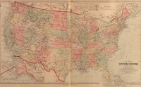
ARTIST: Frank Gray
PUBLISHER: Published by O. W. Gray & Son, Philadelphia.
MEDIUM: Engraving handcolored,
DATE: 1877
EDITION SIZE: Image size 15 1/2 x 13" (395 x 326 mm).
DESCRIPTION: From "Gray's Atlas of the United States." A detailed city plan, naming streets and showing parks and political wards. Also included are plans of East St. Louis, Brooklyn and Venice, across the Mississippi River.
ADDITIONAL INFO:
CONDITION: Good condition and color.
REFERENCE:


 Login / Register
 Basket