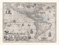
ARTIST: Jodocus Hondius
PUBLISHER: Published by Michaell Sparke, London
MEDIUM: Copper plate engraving,
DATE: 1607 (1635-7)
EDITION SIZE: 5 3/4 x 7 1/4" (14.8 x 18.4 cm) plus margins.
DESCRIPTION: One of the most desirable early small maps of the American Southeast.<br><br> The cartography is based upon the larger Mercator-Hondius 1606 map, which was the most important type map of the region until Ogilby's 1671 map of Carolina. The area shown runs from St. Augustine north to Chesapeake Bay. John Smith's firsthand information was not yet available, so the Chesapeake as shown bears little resemblance to its actual geography. This reduced version of the map was first issued by Jodocus Hondius, appearing in his "Atlas Minor" which itself was a reduced version of Mercator’s "Atlas." In the early 1620's The original copper plates were obtained by several London booksellers and were reprinted in "Purchas His Pilgrimage" (1624-26) and "Historia Mundi or Mercators Atlas." (1635, 37 and 39) This particular impression appeared in the 1637 edition of "Historia Mundi" published by Michaell Sparke. Sparke supplemented the original titles with English titles in the left margin. English text of verso.
ADDITIONAL INFO: This example has one leaf of accompanying descriptive text in English.
CONDITION: Very good condition. Black & white. Text bleed through because of thin paper.
REFERENCE: Burden, The Mapping of North America #155; Cumming, Southeast, 37.


 Login / Register
 Basket