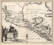
ARTIST: Arnoldus Montanus
PUBLISHER: Published by Jacob van Meurs, Amsterdam.
MEDIUM: Copper plate engraving,
DATE: 1671.
EDITION SIZE: Image size 11 1/4 x 14 3/8" (286 x 363 mm).
DESCRIPTION: A fine map of Guiana from Montanus' "De Nieuwe en Onbekende Weereld: of Beschryving van America." The map depicts Guiana and the Amazon and includes the islands of Trinidad and Tobago. The mouths of both the Amazon and the Orinoco River are also depicted. As with many seventeenth century maps of the region, the chart includes the large fictitious lake Parime Lacos, which never actually existed but was stubbornly reproduced in European maps for over a century. It also includes the mythical city of El Dorado, on the western shore of the lake, which likewise was fictitious.
ADDITIONAL INFO:
CONDITION: Good condition save three short repaired tears from bottom. Black and white.
REFERENCE:


 Login / Register
 Basket