Price: $6,000.00
SKU: 69871
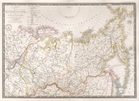
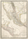
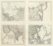
ARTIST: Adrien Hubert Brue
MEDIUM: Copper plate engraving,
DATE: 1815
EDITION SIZE: Four sheet map. Each image measures 21 1/4 x 37" (540 x 687 mm) plus margins.
DESCRIPTION: A highly detailed large scale map that was first issued is Brue's "Grand Atlas Universel,..." In the west cartographically, Brue used the information from and gave credit to Vancouver, Humboldt, Arrowsmith, Pike, Lafora and Lewis & Clark. Zebulon Pike's "Grand Pic" is shown. First state of two.
ADDITIONAL INFO: Two maps trimmed on two sides for joining. A very fine example of this map.
CONDITION: Good condition. Original outline color.
REFERENCE: Wheat "Transmississippi" #321


 Login / Register
 Basket