Price: $2,650.00
SKU: 671
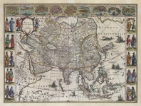
ARTIST: Willem Blaeu
PUBLISHER: Published by W. Blaeu, Amsterdam.
MEDIUM: Handcolored copper plate engraving,
DATE: 1640, c.1650.
EDITION SIZE: Image size 15 1/4 x 19 7/8" (385 x 502 mm) plus margins.
DESCRIPTION: A fine example of this map which is based on the larger 1606 Mercator-Hondius map. It covers an area from the mouth of the Chesapeake Bay to Georgia. On this map a number of settlements are named including Jamestown (est. 1609) and Newport News (est. 1621). One of the great early obtainable maps of the southeast.
ADDITIONAL INFO:
CONDITION: Good condition. Original hand coloring.
REFERENCE: Burden, â??Mapping of North Americaâ?? #253; Cumming, â??Southeast in Early Mapsâ?? #41.


 Login / Register
 Basket