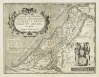
ARTIST: Abraham Ortelius
PUBLISHER: Published by Abraham Ortelius, Antwerp.
MEDIUM: Handcolored copper plate engraving,
DATE: 1584-c.1603.
EDITION SIZE: Image size 14 1/2 x 18 1/2" (36.6 x 47.2 cm) plus margins.
DESCRIPTION: This fine map by Ortelius is the first western printed map of the Country. It is signed in the plate "Ludovico Georgio" whose real name was Luis Jorge de Barbuda. He was a Portuguese Jesuit who produced an early history of China from which this map was drawn. The maps shows China with the north oriented on the right. Includes parts of Southeast Asia, the Philippines and parts of Japan. The Great Wall of China is shown as well. Tartar "yurts" or travelling tents and early land sailing carriages are shown on the plains and steppes of central and eastern China. <br><br>
ADDITIONAL INFO: This impression is from an edition with Spanish text and "109" on verso.
CONDITION: Good condition save for some splitting along upper neat line and a few tiny opposing worm holes. Moderate mat line. Original hand coloring
REFERENCE: #164 in "Ortelius Atlas Maps - An Illustrated Guide" by Marcel Van den Broecke.


 Login / Register
 Basket