ARTIST: Jacques Bellin
PUBLISHER: Published by Jacques N. Bellin, Paris.
MEDIUM: Copper plate engraving,
DATE: 1764
EDITION SIZE: Image size 9 1/16 x 14 1/16" (23.1 x 35.7 cm) plus margins.
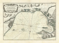
DESCRIPTION: A fine early map focused on the region in Haiti containing Cap-Haitien. This map is from Bellin's "Le Petit Atlas Maritime, ou Recueil de Cartes et de Plans des Quatre Parties du Monde". This atlas or pilot is a wonderful French produced small sized work that depicted a great many parts of the known world.
ADDITIONAL INFO:
CONDITION: Good condition with original hand-color.
REFERENCE:


 Login / Register
 Basket