Price: $150.00
SKU: 32276
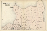
ARTIST: F. W. Beers
PUBLISHER: Published by Beers, Comstock & Cline, New York.
MEDIUM: Hand colored engraving.
DATE: 1873.
EDITION SIZE: 15 1/2 x 24 1/8" (39.3 x 62.2 cm).
DESCRIPTION: "Astoria. Part of Long Island City, Town of Newtown, Queens Co., L.I."—Plates 49 and 50 from the Atlas of Long Island, New York—offers a meticulously detailed view of the neighborhood around Main Street, Astoria as it appeared in 1873. This map is a treasure trove of historical data, vividly capturing the area's bustling activity during the late 19th century. It includes intricate details such as the names of property owners, locations of steamboat landings, and the placement of coal yards, providing a comprehensive snapshot of Astoria’s economic and social landscape at the time. The map serves as a vital resource for understanding the transformation of the area from a predominantly rural community to an industrious urban sector. For historians, urban planners, and local residents alike, this map is not only a fascinating artifact but also an essential tool for tracing the architectural and cultural evolution of Queens, offering insights into the daily lives of its 19th-century inhabitants and the infrastructural advancements that shaped their environment.
ADDITIONAL INFO: This piece is in a 16.5 x 26 inch archival mylar for handling.
CONDITION: Good condition with original color.
REFERENCE:


 Login / Register
 Basket

![Adams. [and] Hancock. [Towns of].](https://oldprintshop.com/uploads/jpg/24298_productthumb.jpg)