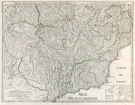
ARTIST: Guillaume De L'Isle
PUBLISHER: Printed for T. Bowles in St. Pauls Church Yard. John Bowles & Son in Cornhil, & Robt. Sayer in Fleet Street
MEDIUM: Copper plate engraving,
DATE: Undated, c. 1755.
EDITION SIZE: 18 3/4 x 24 3/8" (47.5 x 62 cm) plus margins.
DESCRIPTION: A fine English produced historical map of the Western Mediterranean, from Gibraltar to the Balkans. Includes Italy, Sicily, Sardinia, Corsica, Spain and the Balearic Islands to Morocco, Algeria, Tunisia and Libya. Engraved by John Senex.
ADDITIONAL INFO:
CONDITION: Fair to good condition. Staining along horizontal fold.
REFERENCE:


 Login / Register
 Basket