Price: $425.00
SKU: 92751
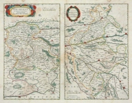
ARTIST: Joannis Blaeu
PUBLISHER: J. Blaeu, Amsterdam.
MEDIUM: Hand-colored copper plate engraving,
DATE: c.1660.
EDITION SIZE: Image size 16 1/4 x 19 5/8" (41.3 x 49.9 cm).
DESCRIPTION: This fine map of the peninsula of Kintyre. Kintyre is located in western Scotland, in the southwest of Argyll and Bute. The peninsula stretches about 30 miles, from the Mull of Kintyre in the south to East Loch Tarbert in the north. This map was based on the work of Timothy Pont. Pont surveyed Scotland between 1595 and 1608. Unfortunately, Pont's maps were not published during his lifetime. This map appeared in Blaeu's atlas Scotland. A handsome map.
ADDITIONAL INFO:
CONDITION: Good condition save some faint damp staining in the margins. Fine original outline coloring.
REFERENCE:


 Login / Register
 Basket