Price: $525.00
SKU: 96051
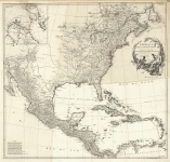
ARTIST: Jean Baptiste D'Anville
PUBLISHER: Published by the Homann Heirs, Nuremberg.
MEDIUM: Copper plate engraving
DATE: 1777.
EDITION SIZE: Image size 17 3/4 x 19 3/4" (45.5 x 50.1 cm).
DESCRIPTION: A fine German produced map of the Colonies first issued in 1756 during the French & Indian War. Some of the interesting features include a truncated Pennsylvania and Virginia, North & South Carolina, Georgia and West Florida and extends westward to the Mississippi. Many Indian tribes are noted. The map is annotated in German. Cartographically, the map is based work of Jean Baptiste D'Anville. <br><br>
ADDITIONAL INFO: 2nd edition of two.
CONDITION: Good condition save for some splitting along upper and lower centerfold. Original outline color.
REFERENCE:


 Login / Register
 Basket