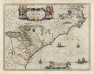
ARTIST: Willem Blaeu
MEDIUM: Copper plate engraving,
DATE: c.1640.
EDITION SIZE: image 15 x 19 5/8" (38.4 x 50 cm).
DESCRIPTION: A fine regional map of France, showing the area between the Saone, Rhone and Dain Rivers. Thew city of Lyon is in the lower right corner. Includes Lion, Challamont, Ville Franche, Mascon, Pont de Vaux, S. Jullien, Monrevel, S. Trivier, S. Amour, Trefort,, etc. Two large decorative cartouches, each flanked by putti, and a coat coat of arms. This map appeared in Blaeu's "Theatrum Orbis Terrarum, Sive Atlas Novis."
ADDITIONAL INFO: French text on verso.
CONDITION: Good condition save for some faint damp stains. Original had coloring.
REFERENCE:


 Login / Register
 Basket