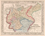
ARTIST: Samuel Augustus Mitchell
PUBLISHER: Published by S. A. Mitchell, Philadelphia.
MEDIUM: Handcolored engraving,
DATE: 1860-63.
EDITION SIZE: Image size 10 5/8 x 13 3/8" (270 x 340 mm) plus margins.
DESCRIPTION: A decorative map from Mitchell's "New General Atlas." Nicely embellished with a rose, flower and ivy vine border.
ADDITIONAL INFO: 1860 edition. With the unusually bright original hand coloring.
CONDITION: Good condition.
REFERENCE:


 Login / Register
 Basket