ARTIST: Braun and Hogenberg
PUBLISHER: Published by Braun & Hogenburg, Cologne.
MEDIUM: Copper plate engraving,
DATE: 1572
EDITION SIZE: Image 13 1/2 x 19" (34.2 x 45.5 cm)
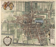
DESCRIPTION: Paris as it was in the 16th century. This plan is based on Sebastian Munster's map of 1569. The city began as a small settlement on an island in the Seine, named Lutetia by the Gallii Parisii. This island controlled the trade in the region both along the river and via the north-south roads crossing the island. The city grew through successive periods, with walls, citadels, and forts added through a series of expansions. The Bastille is shown at the upper center of the engraving and Notre-Dame cathedral is on the eastern end of on the island. The plan is oriented with north on the left.<br><br> This plan appeared in Braun & Hogenberg's "Civitates Orbis Terrarum" which was published in Cologne between the years 1572 and 1617. This great atlas of town plans was edited by Georg Braun and engraved largely by Franz Hogenberg. When the final volume was completed it contained 546 prospects, bird-eye views and map views of cities from all over the world.<br><br> Latin text on verso.
ADDITIONAL INFO:
CONDITION: Good condition and color.
REFERENCE:


 Login / Register
 Basket


![Traiectum ad Mosam. (Mastricht). [Maastricht]](https://oldprintshop.com/uploads/jpg/80511_productthumb.jpg)