ARTIST: Andrew Ellicott
PUBLISHER: Published in London by H. D. Symonds & J. Ridgeway.
MEDIUM: Copper plate engraving,
DATE: 1795.
EDITION SIZE: Image size 15 5/8 x 20 5/8" (39.8 x 52.4 cm).
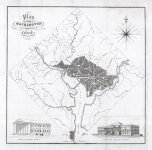
DESCRIPTION: In 1789, discussions began regarding a new federal capital city for the young United States. However, any decision on the capital was put on hold until July 1790 when Congress passed the Residence Act. This Act provided for a national capital and permanent seat of government to be established at a site along the Potomac River and empowered President Washington to appoint commissioners to oversee the project. On January 24, 1791, President George Washington announced the Congressionally-designated permanent location of the national capital, a diamond-shaped ten-mile tract at the confluence of the Potomac and Eastern Branch Rivers. The original survey of the 100-square-mile diamond shaped "district" was undertaken by Andrew Ellicott and Benjamin Banneker (a free slave). In March of 1791, Major Pierre Charles L'Enfant was appointed by George Washington to prepare the plan for the city itself with Ellicott as his assistant. Unfortunately, L'Enfant turned out to be very difficult to work with. Eventually, both Washington and Jefferson became disgusted with L'Enfant's obstinacy which led to his being suspended in 1792 and outright termination in 1793. Ellicott took over the project using L'Enfants plan as a base.<BR><BR> In 1792 Ellicott issued his “official” plan for the city with the idea that at or around the year 1800, the new Capital would be completed. <BR><BR> This English produced plan of the city is based on Ellicott's map of 1792 and appeared in "An American Atlas" published in London by H.D. Symonds & J. Ridgeway. Engraved by J. Russell. It is a bold and well engraved plan.
ADDITIONAL INFO: A very nice impression. Framed to museum quality standards in a 1 3/4" black & metal leaf molding. Laid onto a silk-wrapped rag back, stripped away from the ultra-violet protective glazing
CONDITION: Good condition, save for some minor splits along fold lines. Black and white.
REFERENCE: Phillips "Washington" PW #33; Ristow, "American Maps," p. 153; Verner, 13.


 Login / Register
 Basket