Price: $425.00
SKU: 33248
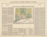
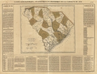
ARTIST: Jean Buchon
MEDIUM: Copper plate engraving.
DATE: 1825
EDITION SIZE: 17 1/2 x 24 3/4" (448 x x 630 mm) including text, plus margins.
DESCRIPTION: This fine early map is from a French produced version of the Carey & Lea atlas, "A Complete Historical, Chronicle, and Geographical American Atlas." The descriptive text describes the history, rivers, climate government, etc.
ADDITIONAL INFO:
CONDITION: Good condition save for repaired splitting along lower centerfold and some minor stains in the upper right and left corners in the margins. Original hand coloring.
REFERENCE:


 Login / Register
 Basket