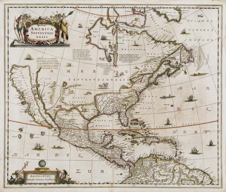
ARTIST: Henricus Hondius
PUBLISHER: Published by Henry Hondius, Amsterdam.
MEDIUM: Copper plate engraving,
DATE: 1636 (1639).
EDITION SIZE: Image size 18 1/4 x 21 1/2" (462 x 547 mm) plus margins.
DESCRIPTION: This fine map is one of the few 17th-century maps to show just North America. It is also the first folio sized map to show California as an island and was likely the single most important in perpetuating the myth. Cartographically, this map is taken from a number of sources. The West Coast is from Henry Briggs's map of 1625 and the Gulf of Mexico and Florida are based on the work of Hessel Gerritsz, c.1631. The east coast and northeast in general are largely from a number of different sources including the work of Capt. John Smith and Johannes de Laet. The map only shows a hint of the Great Lakes and basically nothing of the Mississippi. It is beautifully embellished. Surrounding the title cartouche are images of various native inhabitants of the continent. Shown off both coasts are sailing vessels and sea monsters and in the interior are depictions of animals, including deer, antelope, horses, beavers, and foxes.
ADDITIONAL INFO:
CONDITION: Good condition. Original handcoloring.
REFERENCE: McLaughlin, G., "California as an Island" #6; Burden, P., "Mapping of North America." #245.


 Login / Register
 Basket