Price: $285.00
SKU: 55049
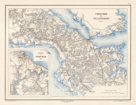
ARTIST: Edouard Dumas Vorzet
PUBLISHER: Published by Librairie Nouvelle, Paris.
MEDIUM: Three-color lithograph,
DATE: 1874
EDITION SIZE: Image size 10 1/16 x 13" (253 x 329 mm).
DESCRIPTION: Lithographed by L. Wuhrer. From the French Civil-War atlas "Histoire de la Guerre Civille en Amerique" by Michel Levy freres. This scarce map is very detailed, depicting northern Maryland between Baltimore and Hancock, southern Pennsylvania, and the Harper's Ferry area in northeastern Virginia.
ADDITIONAL INFO:
CONDITION: Good condition and color.
REFERENCE:


 Login / Register
 Basket


![Bristow Station (Virginia) [and] Brandy Station (Virginia). Pl. XXVII.](https://oldprintshop.com/uploads/jpg/55047_productthumb.jpg)