Price: $450.00
SKU: 27684
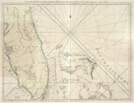
ARTIST: Thomas Jefferys
PUBLISHER: Printed and Sold by R. Sayer and J. Bennett, Map, Chart, and Print Sellers...
MEDIUM: Copper plate engraving with outline color,
DATE: 1775.
EDITION SIZE: Image size 18 7/16 x 24 1/8" (469 x 612 mm).
DESCRIPTION: Title continues: "Composed from a great number of actual Surveys; and other materials regulated by many new Astronomical Observations of the Longitude as well as Latitude." Included beneath the title cartouche is a list of "Observations on which this map is Grounded."
ADDITIONAL INFO:
CONDITION: Good condition. Black & white
REFERENCE: Kershaw #745.


 Login / Register
 Basket