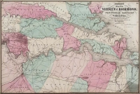
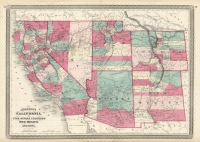
ARTIST: A. Johnson
PUBLISHER: Published by Johnson & Browning, New York.
MEDIUM: Engraving handcolored,
DATE: 1861 (1883)
EDITION SIZE: Image size 22 x 15 1/4" (559 x 387 mm).
DESCRIPTION: Maps of Turkey, Persia and Arabia. This map was published in "Johnsons New Illustrated Family Atlas of the World." A nice bright and well colored impression of this map. Map illustrates cities, towns, and territories. A finely engraved calligraphic border surrounds the image.
ADDITIONAL INFO: From an 1883 edition.
CONDITION: Good condition and color.
REFERENCE:


 Login / Register
 Basket