Price: $275.00
SKU: 62484
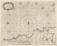
ARTIST: John Seller
PUBLISHER: Published by Mount and Page, London.
MEDIUM: Copper plate engraving,
DATE: c. 1716.
EDITION SIZE: Image size 16 1/8 x 20" (408 x 509 mm).
DESCRIPTION: From "The English Pilot," the famous, ever-changing collection of English seacharts published in the late 17th and 18th centuries. This chart shows part of the western Mediterranean Sea between the coasts of southern Spain and modern-day Algeria.
ADDITIONAL INFO:
CONDITION: Good condition save a few small rust spots.
REFERENCE:


 Login / Register
 Basket