Price: $18,500.00
SKU: 63414
ARTIST: Joseph Bouchette
PUBLISHER: Published by William Faden, London. Engraved by J. Walker.
MEDIUM: Copper plate engraving
DATE: 1815
EDITION SIZE: Multi-sheet segmented wall map. Approximate, overall size 276.6 x 274.4" (697 x 728 cm)
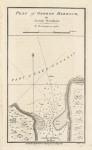
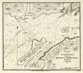
DESCRIPTION: Bouchette’s Map of Canada – A rare and very fine large scale composite map of Canada produced at the end of the War of 1812.<br><br> Highly detailed, the map was drawn on a scale of 24 miles to an inch, ‘shewing its division into districts, counties, seigniories and townships with all the lands reserved both for the crown and clergy’.<BR><BR>Bouchette had been appointed Surveyor General in 1804, and in 1814 his project to produce a large scale map of the province was ready and presented before the House of Assembly. A public subscription was launched, and he left for England in April that year to arrange for publication; here the project met with so much favour that the cartouche carries Bouchette’s dedication to the Prince of Wales. This map was published by William Faden in London and engraved by J. Walker. It is a 3-map compilation intended to accompany Bouchette’s text – A Topographical Description of the Province of Lower Canada. Bouchette was the Surveyor General of Lower Canada from 1804 to 1841, the year he died. Thomson (Men and Meridians, pp. 264-269) calls this production “Bouchette’s magnus opus”. David Rumsey states – “The large ten sheet map is extraordinary – it is over ten feet long when joined and almost five feet tall. It has five views and three large inset maps of Montreal, Quebec and Three Rivers. The detail and graphic elegance of the large map is the equal (or perhaps the superior) of any of the contemporary maps that I have seen”. <BR><BR>The map and the accompanying text was officially sponsored by the Canadian Legislature. In February 18, 1814 Bouchette presented before the House of Assembly his project to produce a large-scale map of Lower Canada accompanied by a topographical dictionary; the assembly referred it to a special committee which brought in a favourable report on 23 February. Meeting in committee of the whole, the house decided to place £1,500 at Bouchette’s disposal. A public subscription was also launched, the fee being five guineas payable on receipt of the map. The majority of the subscribers were English-speaking, a clear indication of the privileged links between Bouchette and this community. With the assurance of the assembly’s backing, Bouchette left for England in August 1814 to arrange for publication of his work. The monumental 10-sheet map of Lower Canada is in two parts – the eastern part in 4 sheets with its own border and the western part in 6 sheets with its own border. They can be joined together, trimming the appropriate borders of each part, to form a 10-sheet map with its own complete surrounding border.
ADDITIONAL INFO: Two leather slip cases. Cases worn but intact. Each bearing two bookplates. Along with Topographical Description of the Province of Lower Canada. London: for the author by W. Faden, 1815. 8vo Engraved frontispiece portrait, 15 maps and aquatint views, some maps folding, 2 letterpress tables. (Heavy stains to frontispiece, title, preliminaries and end leaves, a few plates spotted, folding map of the Ottawa River soiled at inner margin, browned and frayed at outer margin, folding map of the River du Loup cleanly torn.) Late 19th-century blue half calf (cover detached, extremities worn). <BR><BR>This example of the atlas comes with the provenance of James Duke of Montrose (armorial bookplate); Myles Storr Nigel Kennedy (bookplate); Peter Winkworth, Christies, South Kensington, 1 April, 2015.
CONDITION: Map is overall in very good condition, original linen, some moderate offsetting.
REFERENCE: Sabin 6849.


 Login / Register
 Basket