Price: $3,250.00
SKU: 64053
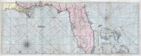
ARTIST: Thomas Jefferys
PUBLISHER: London, printed for Robt. Sayer, Map and printseller, No. 53 Fleet Street.
MEDIUM: Copper plate engraving, hand colored.
DATE: Feb. 20, 1775.
EDITION SIZE: Image size 18 5/8 x 24 5/8" (473 x 626 mm).
DESCRIPTION: A beautiful nautical chart of Florida and the Bahama issued at the beginning of the American Revolution. Because of its large scale and great detail, it was used by both the British and French navies. Florida's interior was still largely unexplored, but the coastal information regarding bays, safe harbors and soundings is extensive. From Jefferys' "The American Atlas: or A Geographical Description of the Whole Continent of America..."
ADDITIONAL INFO:
CONDITION: Very good condition with wash color.
REFERENCE: Stevens & Tree #26.


 Login / Register
 Basket