Price: $5,500.00
SKU: 635
ARTIST: Hermann Moll
PUBLISHER: Sold by H. Moll over against Deverux Court in ye Strand. . . .
MEDIUM: Engraving,
DATE: c.1719.
SIZE: Two-sheet map joined to form one. 22 3/4 x 38" (57.8 x 9.64 cm) plus margins.
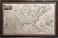
DESCRIPTION: A fine and informative large scale English produced map. Moll attacks the French claims of North America that were shown on Guillaume Delisle's map of the New World. The large vignette shows "ye manner of Fishing for, Curing & Drying Cod at New Found Land." Smaller inset maps include plans of Boston, New York, Charleston, Port Royal, and Havana. California as an island based on the Sanson shape.<br><br> The British hoped to counter Delisle's French claims to “practically all of North America to the west of the Appalachians… Herman Moll presents his counter-blast by reducing French Louisiana to south of the Ohio River and pressing English claims in Canada by labeling Labrador as ‘New Britain’” (Goss).
ADDITIONAL INFO:
CONDITION: Good condition. Short repaired tear in lower portion of map along the centerfold. Some browning along outer wing fold. Fine original outline color.
REFERENCE: McLaughlin "Mapping of California as an Island" #192; Schwartz and Ehrenberg "Mapping of America, #140; Goss "North America" #53.



 Login / Register
 Basket