Price: $160.00
SKU: 67089
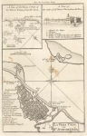
ARTIST: Thomas Kitchin
PUBLISHER: Published in the London Magazine, London.
MEDIUM: Copper plate engraving,
DATE: 1763.
EDITION SIZE: Image size 11 1/8 x 13 5/8" (27.6 x 35.2 cm)
DESCRIPTION: This map, titled "New Map of the Island of Jamaica Divided into its Parishes Including the South End of Cuba and the West End of Hispaniola with the Trade Winds &c." by Thomas Kitchin, was published in 1763 and featured in the July issue of the "London Magazine: or, Gentleman's Monthly Intelligencer." It offers a detailed view of Jamaica, neatly dividing it into parishes, and extends to include the southern tip of Cuba and the western end of Hispaniola, highlighted with indications of the prevailing trade winds. <br><br> This comprehensive depiction captures the strategic and economic significance of the Caribbean region during a time when maritime navigation and the sugar trade were booming. Its detailed rendering makes it an essential piece for historians and collectors alike, providing a snapshot of 18th-century geopolitical dynamics in a key area of colonial interest.
ADDITIONAL INFO: This piece is in a 13.5 x 17.5 inch archival mylar for handling.
CONDITION: Good condition. Black & white.
REFERENCE: LOND-228.


 Login / Register
 Basket