Price: $125.00
SKU: 68569
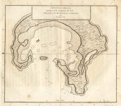
ARTIST: Henry Roberts
PUBLISHER: Published by Order of the Lords Commissioners of the Admiralty. London. 1784.
MEDIUM: Copper plate engraving,
DATE: 1784
EDITION SIZE: 7 3/8 x 8 1/2" 186 x 215 mm) plus margins.
DESCRIPTION: A small chart showing what is now called Cook's Bay on the island of Moorea in the French Polynesia. Lieutenant Henry Roberts was the Masters Mate on Cook's third voyage and was given the task of compiling the surveys for the trip. This chart appeared in; "A Voyage to the Pacific Ocean... for making discoveries in the Northern Hemisphere... Performed under the direction of Captains Cook, Clerke, and Gore, in his Majesty's ships the Resolution and Discovery. In the years 1776, 1777, 1778, 1779, and 1780." The chart is oriented with north toward bottom.
ADDITIONAL INFO:
CONDITION: Good condition save for small stain just above title. Black & white. Narrow lower margin.
REFERENCE:


 Login / Register
 Basket
")