Price: $135.00
SKU: 69309
ARTIST: Jean-Baptiste Crepy
PUBLISHER: Published by the Crepy family of Paris and Marseille.
MEDIUM: Engraving,
DATE: 1767.
EDITION SIZE: 7 3/4 x 10 1/2" (19.8 x 26.7 cm) plus margins.
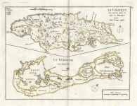
DESCRIPTION: This map, "Ile St. Christophle und des antilles aux anglois" and "La Barbade une des antilles aux Anglois divisee par Paroisses" by Jean-Baptiste Crepy were published in 1767. These maps, originally crafted around 1748 for Le Rouge's "Atlas Nouveau Portatif," were later acquired and reissued by Crepy in Paris, who added his own imprint to the newly issued editions. These prints capture the English-controlled islands of St. Christopher (St. Kitts) and Barbados during a period of intense colonial competition in the Caribbean. <br><br> Each map is meticulously detailed, showing the division of Barbados into parishes and highlighting significant geographical and man-made features of St. Christopher, offering a glimpse into the colonial landscape of the 18th century. Crepy’s enhancements make these maps not only valuable historical documents but also appealing pieces for collectors and enthusiasts of cartographic history. Their detailed portrayal of key colonial territories in the Caribbean makes them excellent additions for those interested in the era's geopolitical dynamics and colonial cartography.
ADDITIONAL INFO: This piece is in a 10 x 14 inch archival mylar for handling.
CONDITION: Good condition. Original outline hand coloring.
REFERENCE: Kapp, K.S. (Jamaica) 64; Palmer, M. (Bermuda maps) p.11.


 Login / Register
 Basket
 La Barbade une des antilles aux Anglois divisee par Paroisses.")