Price: $1,200.00
SKU: 69451
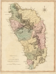
ARTIST: Thomas Jefferys
PUBLISHER: Published by Robert Sayer, map and print seller, London.
MEDIUM: Copper plate engraving,
DATE: 1775
EDITION SIZE: Image size, 23 3/4 x 18 5/8" (604 x 473 mm) plus margins.
DESCRIPTION: A beautiful and finely engraved map of the island from Tho. Jeffreys' "The West Indian Atlas". Place names, Plantations, anchorages, rivers and roads are shown. In the upper left is an inset map "Plan of the Carenage."
ADDITIONAL INFO:
CONDITION: Good condition. Black & white.
REFERENCE:


 Login / Register
 Basket