Price: $1,795.00
SKU: 70256
ARTIST: John Melish
PUBLISHER: Published by J. Starr & Co. New York
MEDIUM: Engraving,
DATE: 1826
EDITION SIZE: 16 1/8 x 20 1/4" (409 x 514 mm) plus hairline margins.
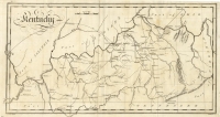
DESCRIPTION: A rare pocket map that shows the Unites States and territories west to the foothills of the Rockies. Includes all of what would become Texas. Shows large “doublewide” Arkansas, here labeled “Arkansa Territory.” Also noted are the Missouri, North West and Michigan Territories. Notes many Indian tribal names, rivers, towns and cities. Not credited to but largely based on John Melish’s earlier map.
ADDITIONAL INFO: Retains original leather covers wit gold embossed title "U. S. Map"
CONDITION: Very good condition. Full original hand color.
REFERENCE:


 Login / Register
 Basket