Price: $85.00
SKU: 72117
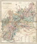
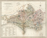
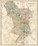
ARTIST: John & Charles Walker
PUBLISHER: Published in London by Longman, Hurst, Rees, Orme & Co
MEDIUM: Engraving,
DATE: 1835
EDITION SIZE: Sheet size 12 15/16 x 15 3/4" (328 x 401 mm).
DESCRIPTION: A finely engraved map from Walkers "British Atlas, comprising seperate maps of each County in England,... Showing the roads, railways, canals, parks, boundaries of boroughs &c."
ADDITIONAL INFO:
CONDITION: Good condition. Original hand coloring.
REFERENCE:


 Login / Register
 Basket