Price: $125.00
SKU: 74355
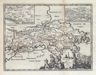
ARTIST: Philip Cluver
PUBLISHER: Published by Johann Pauli, Amsterdam
MEDIUM: Copper plate engraving,
DATE: 1729
EDITION SIZE: 7 3/4 x 10 " (197 x 255 mm) plus margins.
DESCRIPTION: A finely engraved map showing the northern part of Greece which include historical regions of Macedonia and Thesalia. Embellished with a decorative cartouche.. Notes many towns, cities and historical localities. Appeared in "Introductionis in Universam Geographiam...".
ADDITIONAL INFO:
CONDITION: Good condition save for some minor offsetting. Black & white.
REFERENCE:


 Login / Register
 Basket