Price: $200.00
SKU: 75037
ARTIST: Gaylord Watson
PUBLISHER: Published by Gaylord Watson, New York.
MEDIUM: Stone engraving,
DATE: 1891
EDITION SIZE: 19 x 29 1/8" (49.2 x 74 cm) plus margins.
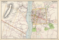
DESCRIPTION: A highly detailed map of the Hudson River from Grassy Point to Jones Point. Across the river is Verplanck. Most land owners names are given. This map appeared in Watson's "Atlas of the Hudson River Valley..."
ADDITIONAL INFO:
CONDITION: Good condition save for chipping along the outer margins.
REFERENCE:


 Login / Register
 Basket
")