Price: $1,750.00
SKU: 6963
ARTIST: Jan Jansson
MEDIUM: Copper plate engraving
DATE: 1636
EDITION SIZE: 15 1/4 x 19 5/8" (38.8 x 50 cm) plus margins.
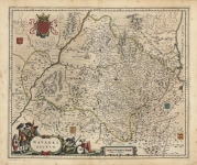
DESCRIPTION: A fine example of Jansson’s highly influential map of the East Coast of North America.<br><br> Shown is an area from Cape Lookout in North Carolina northward to mid Nova Scotia. Jansson based his map upon Johannes De Laet’s map of 1630, which itself was based of the cartography of Hessel Gerritsz. In the interior, this map is one of the earliest to identify any part of the Great Lakes. The larger lake is labeled is “Grand Lac.” According to Karpinski this "is the first printed complete map of Lake Superior" A smaller lake to the east is “Lac des Yroquois” which is either Lake Ontario or Erie. It is also one of the first printed maps to include several important place names including New Amsterdam, (Manhattan), Fort Orange, (Albany), and the English settlement of Plymouth.
ADDITIONAL INFO: French text on verso.
CONDITION: Good condition with old color save small repairs and minor stains in outer margins.
REFERENCE: Burden, #247; McCorkle, #636.1; Karpinski, "Famous Cartographers" pp.26, 31, pl II.


 Login / Register
 Basket