Price: $875.00
SKU: 78319
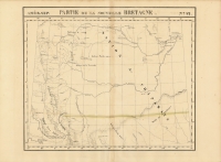
ARTIST: Philippe Vandermaelen
PUBLISHER: Published by P. Vandermaelen, Belgium.
MEDIUM: Lithograph handcolored,
DATE: 1827
EDITION SIZE: Image size 18 3/4 x 20 7/8" (473 x 531 mm) plus margins.
DESCRIPTION: A beautiful map of the upper Mississippi and Missouri River basins here titled, “Territoire du Nord-Ouest” From Vandermaelen's "Atlas Universel de Geographie." The first atlas issued using lithography as the printing medium.
ADDITIONAL INFO:
CONDITION: Very good condition. Original color.
REFERENCE:


 Login / Register
 Basket
")