ARTIST: Jean Francois Galoup La Perouse
MEDIUM: Engraving,
DATE: 1797
EDITION SIZE: 19 1/2 x 26 7/8" (454 x 683 mm) plus margins.
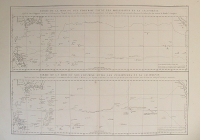
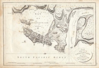
DESCRIPTION: This chart shows Bucareli Bay which is part of the Alexander Achipelago in the southeastern portion of Alaska. La Perouse was selected by King Louis XVI to complete Captain James Cook's exploration of the western Pacific. Jean-Francois de Galaup & Comte de La Perouse commanded a French scientific expedition which set sail from France in 1785. The Boussole & Astrolabe with all aboard was shipwrecked in 1788 but the narrative, maps, and views survived and were published in 1797. La Perouse explored the coasts of the Gulf of Alaska and northwestern North America in search of the fabled Northwest Passage. After leaving America his expedition continued across the Pacific to Asia. This plate is from the French.
ADDITIONAL INFO:
CONDITION: Good condition. Black & white.
REFERENCE:


 Login / Register
 Basket

![Plan of the Port S. Diego in California ... from a Survey in 1782 [on sheet with] Plan of the Port & Department of S. Blas ... from a Survey in November 1777.](https://oldprintshop.com/uploads/jpg/56240_productthumb.jpg)