Price: $650.00
SKU: 80983
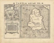
ARTIST: Sebastain Munster
PUBLISHER: Published by Sebastian Munster, Basle.
MEDIUM: Wood engraving,
DATE: 1540 - c.1571.
EDITION SIZE: 9 7/8 x 13 3/8" (25 x 34 cm) plus margins.
DESCRIPTION: A fine early Ptolemaic map of India. The Indus River is delineated in the west, Ganges in the east. The subcontinent is severely truncated and Pars Toprobanae (Sri Lanka) appears where the peninsula should extend.This map appeared in Sebastian Munster’s "Gergraphia Universalis." According to Karrow, the letterpress title on this map indicates it comes from the 1571 edition of Strabo, published by Petri. The 1540 edition of the Geographia has the title, "Tabula Asiae X"
ADDITIONAL INFO: Latin text on verso.
CONDITION: Good condition. Modern hand coloring.
REFERENCE: Karrow, R. W. Mapmakers of the 16th Century" 16c.


 Login / Register
 Basket