Price: SOLD
SKU: 83700
ARTIST: Amos Doolittle
PUBLISHER: Published by Shelton & Kensett, Cheshire, Conn.
MEDIUM: Copper plate engraving,
DATE: 1816
EDITION SIZE: Segmented map, overall 49 1/8 x 55 1/2".
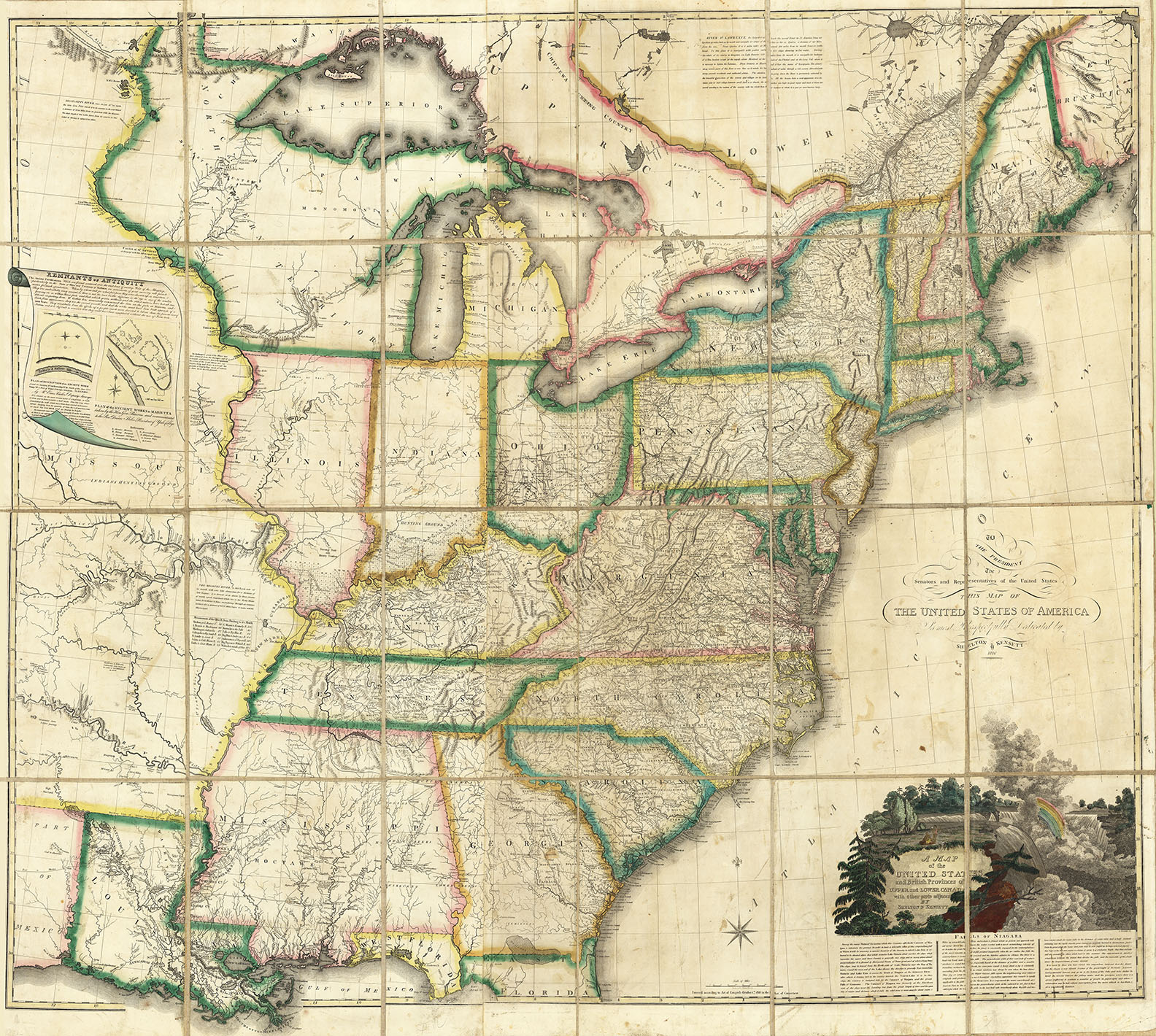
DESCRIPTION: A remarkably detailed large map of the United States engraved and published by the firm of Shelton & Kensett in Cheshire, Connecticut. The map was engraved by Thomas Kensett. The cartouche, with a large image of Niagara Falls, was engraved by Amos Doolittle. Stylistically, this map is based on the Arrowsmith/Tardieu maps of the same period with a similar "Falls of Niagara" cartouche. Interestingly, credit for the cartouche is given to Tardieu, who copied it from Arrowsmith (likely evidence of a prejudice against the British from the War of 1812). Cartographically, this map is far superior to either the Arrowsmith or Tardieu maps. In the west it incorporated both of Pike's maps of the Upper Mississippi and the western tributaries of the Mississippi and the Missouri. East of the Mississippi, it used much from the Bradley "Postal" map of the United States of 1804-1812, including public survey lines, county formations, township boundaries, roads, etc. There are two very interesting inset maps and a commentary on ancient fortifications found along the Ohio River. “This highly detailed and accurate map must be one of the best of its period.” D. Rumsey. This map rarity is likely because it was issued the same year as John Melish’s “Map of the United States with the Contiguous British & Spanish Possessions.” Melish’s map showed the United States from the east coast to the west coast, including the northern Mexican provinces (Texas and California) which in time would become part of the U.S. This shape was more or less taken by the public as Manifest Destiny. Melish’s map was so successful that it likely diminished any demand for all other large scale maps of the growing country. This map is considered to be extremely rare with only a small handful known to exist. There is only one state known of this map but this author has seen some fragments of an example that suggest that a updated version was to be issued. This fragment was found on the verso of three (of four) sheets of the"Prodigal Son" series issued by Shelton & Kensett. These fragments show an Alabama Territory having been carved out of the large Mississippi territory. Alabama Territory was formed in August, 1817. There are no known examples of a completed second state. The project was likely abandoned due to poor sales. The firm of Shelton & Kensett was founded circa 1812 in Cheshire, Connecticut. It issued a number of maps and pints, many of which are quite scarce. Thomas Kensett (1786-1829) was born in England and emigrated to the United States. He was in New Haven in 1806. Amos Doolittle (1754-1832) was born in Cheshire, Connnecticut, and was trained as a jeweler and silversmith. As an engraver, he was self-taught. He produced a number of engravings by himself, with his son, and with the firm of Shelton & Kensett.
ADDITIONAL INFO: Fine original outline color by states. Cartouche also full original handcoloring. Map is printed on four sheets which have been joined, dissected into 24 sections and backed with linen. Folds into the original hard covers. The covers are 3/4-red morocco over marble paper boards with applied green leather gilt stamped title "Shelton & Kensett’s Travelling Map of the United States.” Spine in six compartments separated by gilt bands. Cover measures 12 7/8 x 9 3/8” (327 x 237 mm). Some wear on cover. Signed on inside back cover “Richard Hatfield, Dec. 1817.”
CONDITION: Overall very good condition. There are some occasional worm holes, surface soiling and minor stains. Fine original outline coloring.
REFERENCE: Karrow 1-1422; Schwartz & Ehrenberg p. 235; Karpinski 38.



 Login / Register
 Basket