Price: $2,500.00
SKU: 85073
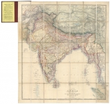
ARTIST: Edward Stanford
PUBLISHER: Published London - Edward Stanford, 6, Charing Cross, May 13th 1861.
MEDIUM: Stone engraving,
DATE: 1861.
EDITION SIZE: Image size 18 5/8 x 22 1/4" (47.3 x 56.5 cm) plus margins.
DESCRIPTION: Constructed & Engrd. at Stanford's Geographical Establishment. London. <br><br> A rare and apparently unrecorded English produced pocket map of the United States at the beginning stages of the Civil War. The map is amazingly detailed for the period, noting hundreds of cities, towns, rivers, mountains, Indian tribes, etc. The new territory of Colorado is now shown and the Dakotas have been carved out of Minnesota. New Mexico and Arizona are shown divided on a east-west boundary. One interesting fact is that it shows the seceded states as of late April, 1861. They are Texas, Louisiana, Mississippi, Georgia, South Carolina and Virginia. Arkansas. The states of Tennessee and North Carolina are still part of the Union. This map had a very limited life as the final three states seceded by the 10th of June, within a month of being issued. Stanford quickly updated the map to show all the seceded states and reissued it with a new title: "Stanford's New Large-Print Map of The United States of North America.”
ADDITIONAL INFO: Retains but removed from original green cloth covers with applied label. On the inner cover is applied advertisement for other pocket-guide maps issued by Stanford.
CONDITION: Map is backed on japon paper. Bright original outline handcoloring.
REFERENCE: Not in Stephenson.


 Login / Register
 Basket