Price: $695.00
SKU: 86316
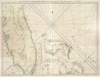
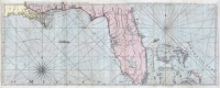
ARTIST: Thomas Jefferys
PUBLISHER: Published by Laurie & Whittle, No. 53 Fleet Street, London
MEDIUM: Copper plate engraving,
DATE: 1775-1794
EDITION SIZE: Image size 18 3/8 x 24 1/4" (462 x 616 mm).
DESCRIPTION: This map, "Jamaica from the Latest Surveys" created by Thomas Jefferys between 1775 and 1794, is a finely engraved map based on detailed surveys conducted during the late 18th century. Jefferys, a prominent British cartographer and Geographer to the King, produced this map as part of The West Indian Atlas, a comprehensive work intended to support navigation and colonial administration in the Caribbean. The atlas was published during a period of heightened British interest in the region, following territorial shifts resulting from the Seven Years' War and amid ongoing economic activity tied to transatlantic trade. The map presents a thorough depiction of Jamaica’s towns, roads, rivers, and topographical features, with maritime details such as anchorages and coastal soundings noted throughout. Communities are labeled across the interior, with certain settlements marked by typographical distinctions based on the conventions of the period. Inset maps in the lower corners provide enlarged views of Bluefields Harbor as well as the Harbors of Kingston and Port Royal, including coastal features and the layout of adjacent areas. The map serves both as a navigational tool and as a reflection of British cartographic practices and territorial management during the late 18th century.
ADDITIONAL INFO: From an 1810 edition.
CONDITION: Good condition. Original hand coloring.
REFERENCE:


 Login / Register
 Basket