Price: $225.00
SKU: 89171
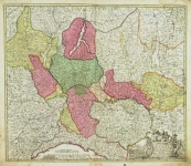
ARTIST: Johann Baptist Homann
MEDIUM: Engraving, hand-colored,
DATE: c.1746.
EDITION SIZE: Image size 18 5/8 x 21 11/16" (47.2 x 55.1 cm)
DESCRIPTION: A map tracing the flow of the Danubi River. It shows the area that makes up present day Switzerland, Liechtenstein, southern Germany (Bavaria and Stuttgart), eastern France, western Austria and Slovenia, and northern Italy and Croatia. The major bodies of water present are the Adriatic Sea, Gulf of Venice, Ligurian Sea and Mediterranean Sea.
ADDITIONAL INFO:
CONDITION: Good condition and color, save a water stain in the lower right corner.
REFERENCE:


 Login / Register
 Basket
 Pars Superior - in qua Suevia, Bavaria, Asutria, Stiria, Carinthia, Carniola, Tyrolis et Helvetia com magna parte Italiae...")