Price: $475.00
SKU: 90021
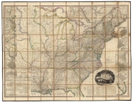
ARTIST: Henry Tanner
MEDIUM: Engraving
DATE: 1840
EDITION SIZE: 12 1/2 x 14 1/2"(31.7 x 36.7 cm) including scrollwork border plus margins.
DESCRIPTION: A fine separately issued pocket map of New York. The base map appeared in Tanner’s Universal Atlas and was first issued in 1834-36. Tanner's Atlas was the forerunner of a series of Atlases continued by Mitchell, Cowperthwait, Desilver, SA Mitchell Jr and others which extended to the early 1890s. This map differs from the atlas version by the addition of the outer green colored scrollwork border. Separately issued pocket maps by Tanner maps are quite scarce.
ADDITIONAL INFO: Bound into original covers.
CONDITION: Fair to good condition. Splitting along fold intersections and small brown stain within image. Professionally conserved and backed on ricepaper.
REFERENCE:


 Login / Register
 Basket