Price: $375.00
SKU: 777
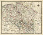
ARTIST: James Wyld
PUBLISHER: Published by J. Wyld, Geographer to the Queen. London.
MEDIUM: Handcolored copper plate engraving,
DATE: 1841
EDITION SIZE: 22 7/8 x 32 3/8" (554 x 823 mm) plus margins.
DESCRIPTION: This map is from Wyld's "A New General Atlas of Modern Geography…". Wyld succeeded William Faden and Thomas Jeffreys as "Geographer to the Queen" as well as having the additional title "to his Royal Highness Prince Albert". His maps are known for their high quality engraving and attention to detail. A nice bright and well colored impression of this interesting map.
ADDITIONAL INFO:
CONDITION: Very good condition. Fine original outline color.
REFERENCE:


 Login / Register
 Basket