Price: $2,950.00
SKU: 92677
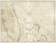
ARTIST: Thomas Jefferys
PUBLISHER: London, Printed for Robt. Sayer, Map and Printseller. No. 53 Fleet Street as the Act Directs, 20 Feby. 1775.
MEDIUM: Copper plate engraving
DATE: 1775.
EDITION SIZE: 18 3/4 x 24 5/8" (47.3 x 62.5 cm) plus margins.
DESCRIPTION: The right hand sheet of Thomas Jefferys map of Florida and the Bahama Islands. This map was issued in two separate sheets that can be joined or kept as separates. This is the eastern sheet shows the peninsula of Florida and the Bahamas. The western sheet shows the Florida pan-handle to the Mississippi delta. This version likely appeared in Jeffrey's West India Atlas rather than the American Atlas. This is the first large format English map to treat the region with remarkable detail, it gives soundings, many place names including many of the Bahama Islands. Embellished with rhumblines and ships under sail. The detail in Florida and the Bahamas is excellent as is the elaborate compass rose and sailing ships.
ADDITIONAL INFO:
CONDITION: Good condition save for some staining in the central right. Modern hand coloring.
REFERENCE: Stevens & Tree "Comparative Cartography" #26B


 Login / Register
 Basket