Price: $325.00
SKU: 93495
ARTIST: George Walker
PUBLISHER: Published by Geo. H. Walker & Co., 81 Milk St., Boston.
MEDIUM: Hand colored lithograph,
DATE: 1880.
EDITION SIZE: Image size 16 3/4 x 25 5/8" (39.8 x 65 cm) plus margins.
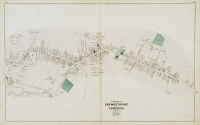
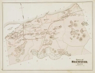
DESCRIPTION: Double-sided map from Geo. H. Walker & Co.’s 1880 ‘Atlas of Barnstable County, Massachusetts.’ The Walker Company was formed in the late 1870s by George Hiram Walker and his brother Oscar. They were very prolific, publishing maps, atlases and bird's eye views of New England locales. One side of this sheet includes three maps, showing parts of the south and west villages of the town of Yarmouth, Massachusetts. The maps detail the locations of privately owned buildings and plots of land along the streets, as well as landmarks such as ponds, churches, cemeteries, and schools. South Yarmouth’s map also includes local salt works and windmills. The reverse side of the sheet includes three maps – one for the town of Yarmouth as a whole, one for the town of Dennis, and one for the village of East Dennis within that town. The full-town maps provide more perspective on the topography of the region as a whole, locating the densely populated smaller regions within their rural surroundings. <br><br>
ADDITIONAL INFO: Some manuscript additions.
CONDITION: Good condition save for occasional minor stain..
REFERENCE:


 Login / Register
 Basket

![Village of Hyannis [and] Town of Barnstable. Village of Hyannis Port including Sea Shore Lots of the Hyannis Land Company.](https://oldprintshop.com/uploads/jpg/43962_productthumb.jpg)